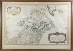


Carte de lAmerique Septentrionale Depuis le 28 Degré de Latitude jusquau 72. By Jacques Nicolas Bellin, Paris 1755. 33 ½ x 21 7/8 (plus broad margins). Hand colored. A very important map by the noted hydrographer and geographer compiling French discoveries and explorations in North America over the prior two decades, with a detailed depiction of Greenland and Iceland. Printed Prix. trente Sols. lower right. Very Good. Attractively framed, 38 ¼ x 26 7/8.